
India(ISRO) ans USA (NASA) launch satellite NISARA
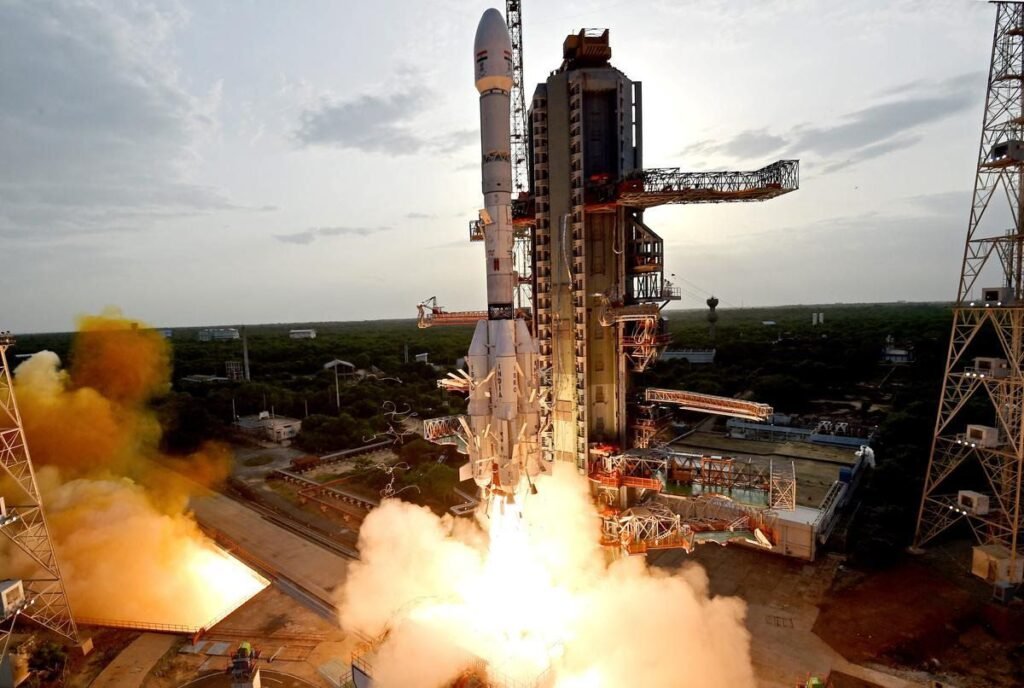
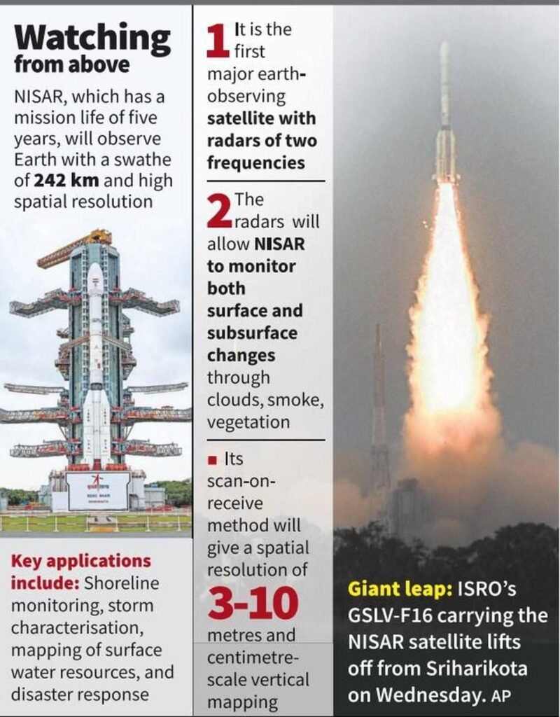
Sriharikota, Petu : The NISAR satellite was put into orbit on Wednesday with a successful launch of the GSLV rocket as part of a partnership between the Indian Space Research Organisation (ISRO) and the US space agency NASA. The satellite will map the earth every 12 days using a 240-km-wide radar field, providing data to scientists and disaster response agencies to monitor everything from the retreat of glaciers in the Himalayas to potential landslide zones in South America.
The NASA-ISRO Synthetic Aperture Radar (NISAR) satellite has been jointly developed by the two space agencies. Though ISRO has launched earth observation satellites in the past, including Resourcesat and RISAT, the data collected from these satellites.
The GSLV-
F16 rocket launched with NISAR satellite from Sriharikota on Wednesday was restricted to Indian territory. Reuters ISRO and NASA have jointly launched a satellite for the first time that will keep an eye on the entire earth.
ISRO’s GSLV F-16 put the NISAR satellite in a sun synchronous polar orbit (SSPO) at a distance of about 745 km after a flight of about 19 minutes, marking a successful collaboration between the world’s two top space agencies. ISRO Chairman V
Monitoring earthquake and landslide prone areas
The NISAR satellite will provide 3-D images of the earth’s land and ice. With its ability to see through clouds and rain day and night, the satellite will enable data users to monitor earthquake and landslide prone areas and determine how fast ice sheets are changing.
I am very happy to announce that GSLV F-16 has successfully put the NISAR satellite into orbit, Narayanan said.
Wednesday’s mission was reportedly the world’s most expensive, with an estimated cost of $1.5 billion. Apart from this, it was also the first GSLV mission to a sun-synchronous polar orbit. Till now all GSLV missions have gone to Geosynchronous Transfer Orbit (GTO). Being a SSPO mission, many analyses and studies were done to make it completely successful.
https://science.nasa.gov/video-detail/amf-542869cb-eabf-4bbc-b0d7-7951c04f54c9/
Narayanan said that the performance of all vehicle systems was normal as per expectations and predictions. Today we have achieved the desired orbit. In fact, we have achieved an orbit with a dispersion (deviation from the desired orbit) of less than three km compared to the acceptable level of 20 km… All parameters are as per expectations. At the same time, NASA said that the data obtained from NISAR will provide important inputs to the government and administration in planning to deal with natural and man-made threats. NISAR can help in hazard monitoring efforts and potentially give the administration more time to prepare to deal with a potential disaster.
The NASA-ISRO SAR (NISAR) Mission will measure Earth’s changing ecosystems, dynamic surfaces, and ice masses providing information about biomass, natural hazards, sea level rise, and groundwater, and will support a host of other applications.
NISAR will observe Earth’s land and ice-covered surfaces globally with 12-day regularity on ascending and descending passes, sampling Earth on average every 6 days for a baseline 3-year mission.
Mission Characteristics
- Orbit Altitude 747 km
- Orbit Inclination 98.4° Repeat Cycle12 days.
- Time of Nodal Crossing 6 AM/ 6 PMOrbit Control< 500 mPointing Control< 273 arcsec.
- PointingLeft (south)L/S Duty Cycle> 50%/10% Baseline Mission.
- Duration 3 years Consumables 5 years Data and Product AccessFree & open.
- Wavelength L-band: 24 cm
S-band : 9 cmSAR .
Resoluti on 3–10 m mode-dependent.
Nisar will keep a sharp eye on the earth
First collaboration between NASA-ISRO successful
Satellite placed in designated orbit
About this mission
Indian Space Research Organization (ISRO) and American Space Agency NASA placed the jointly developed satellite Nisar for monitoring the earth in the designated orbit on Wednesday. This was the first collaboration between the two agencies in the space sector. After separating from the GSLV F-16 rocket, it may take several days to operate the satellite properly in orbit. Nisar will help India keep a sharp eye on the earth. It is an all-weather satellite capable of taking pictures during day and night, which will be able to scan the entire earth at an interval of 12 days. Agency
Journey of 745 km to polar orbit in 19 minutes
The 51.7 meter long launch vehicle took off on Wednesday at its pre-scheduled time of 5:40 pm from Satish Dhawan Space Center carrying a satellite weighing 2,393 kg. ISRO said, the NASA-ISRO Synthetic Aperture Radar Satellite (NISAR) was launched by India’s GSLV F-16 into a Sun Synchronous Polar Orbit (SSPO) covering a distance of 745 km in about 19 minutes. This achievement is big for ISRO because its attempt to put the EOS 01 satellite in the desired orbit through PSLV C-61 on May 18 had failed.
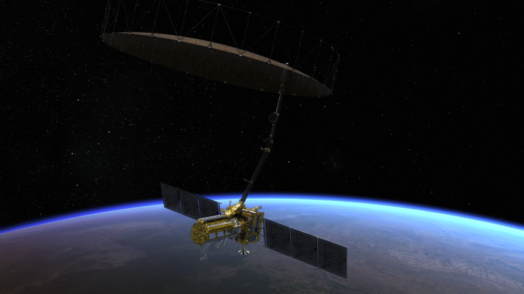
ISRO Chairman V. Narayanan said after the 102nd launch from Sriharikota, GSLV F-16 has successfully placed the NISAR satellite in orbit. This satellite integrates ISRO’s S-band synthetic aperture radar with NASA’s L-bandR payload and 12 meter unflappable antenna. It is the first dual frequency satellite of its kind.
13,000
Crores cost… world’s most expensive mission
NASA-ISRO partnership:
It is being told that this was the world’s most expensive mission, whose estimated cost is more than 1.5 billion US dollars i.e. about 13,000 crores rupees. This was the first GSLV mission for SSPO. Till now all GSLV missions have gone to geosynchronous transfer orbit (GTO) only.
The S-band radar system, data handling and high-speed downlink system, spacecraft and launch system in the satellite have been developed by ISRO. L-band radar system, high-speed downlink system, solid state recorder, GPS receiver, 9 meter boom hoisting and 12 meter reflector have been provided by NASA.
ISRO will command and operate the satellite, while NASA will help in orbit change planning and radar operation planning.
Read these articles
Artificial intelligence
https://thenewspoint.in/artificial-intelligencea-new-era/
Brics summit
https://thenewspoint.in/brics-summit-major-outcomes-of-the-brics-summit/
5G technology
https://thenewspoint.in/5g-technology-how-5g-is-changing-the-world/
Electric vehicles
https://thenewspoint.in/electric-vehicles-the-future-of-transportation/
I phone 16
https://thenewspoint.in/iphone-16-a-simple-and-powerful-smartphone/
